Run With Me Seoul · the app
Water fountains, toilets and a CU, on the map before you need them.
The Run With Me Seoul app carries 7,274 public water fountains, public toilets and convenience stores in Seoul on the same map you run on. They ship inside the app, so it answers "where is the next tap" at kilometre 18 with no signal and nothing downloaded first.
Free. iOS and Android.
- 7,274
- taps, toilets and stores mapped across Seoul
- 0
- downloads needed. They ship inside the app
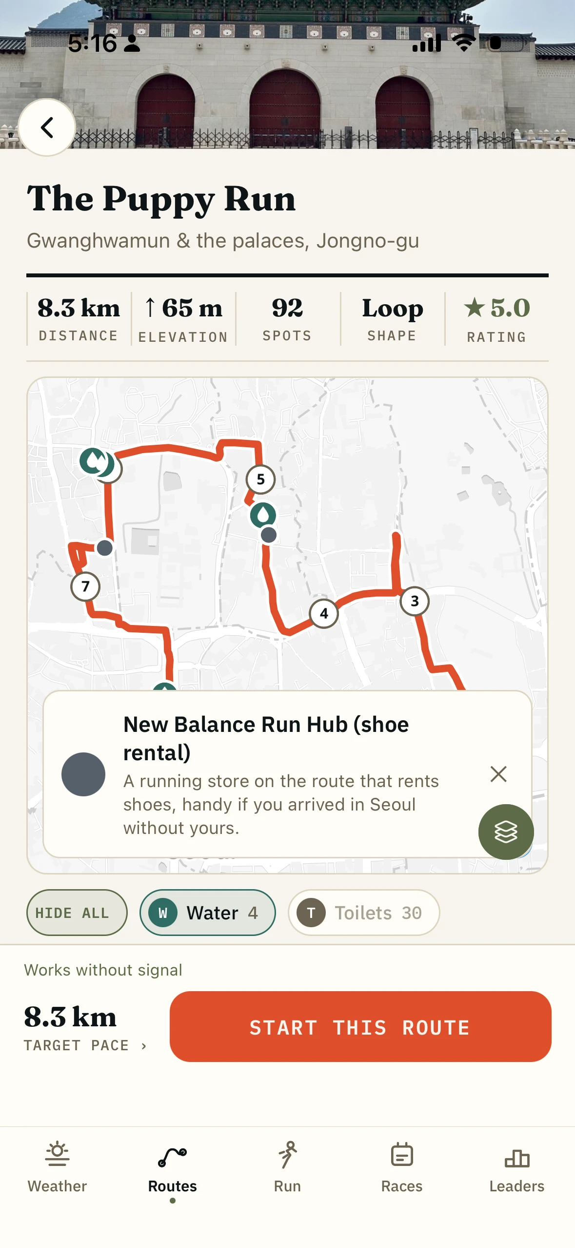
- 15 toilets
- and 7 water fountains on the median 10km in the app
How the amenity map works.
01
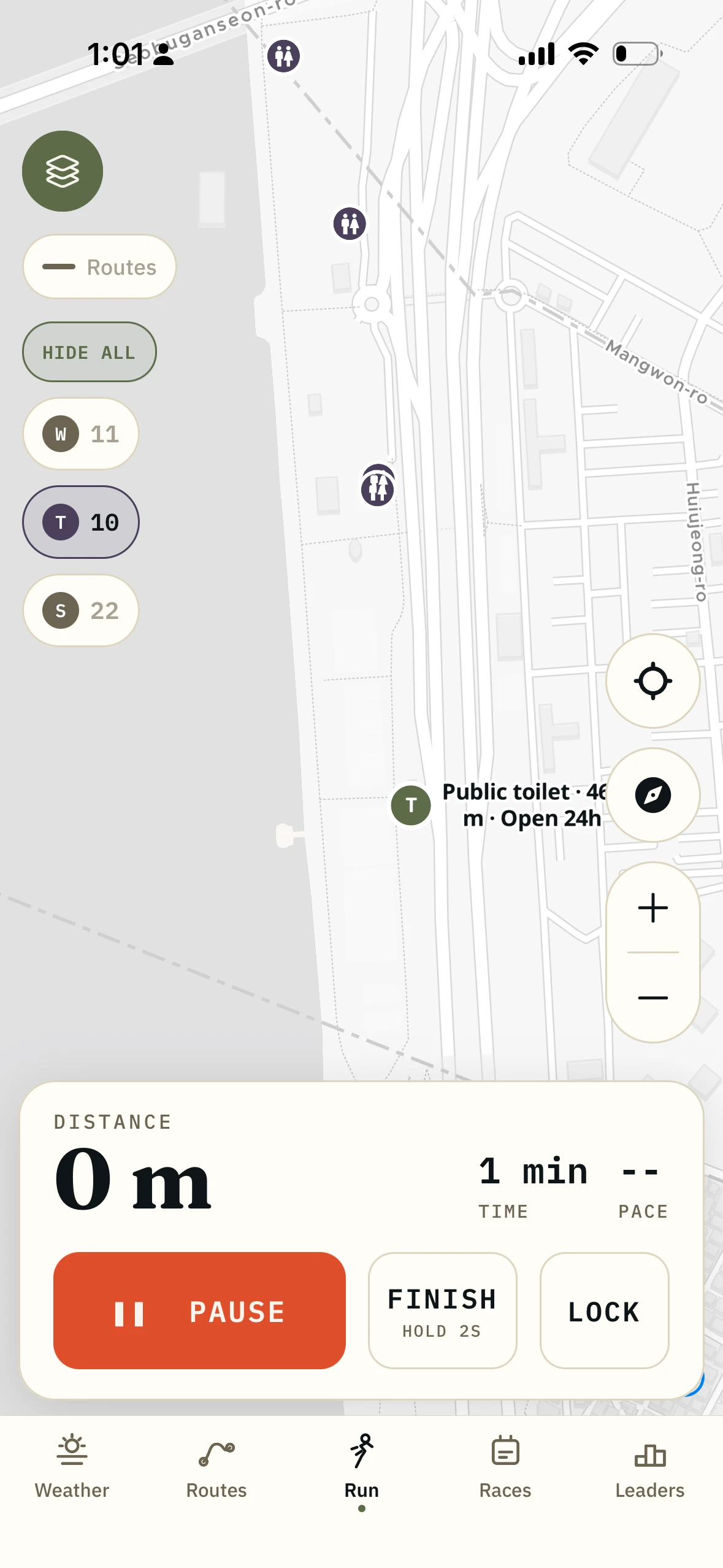
Turn on toilets and tap the nearest pin.
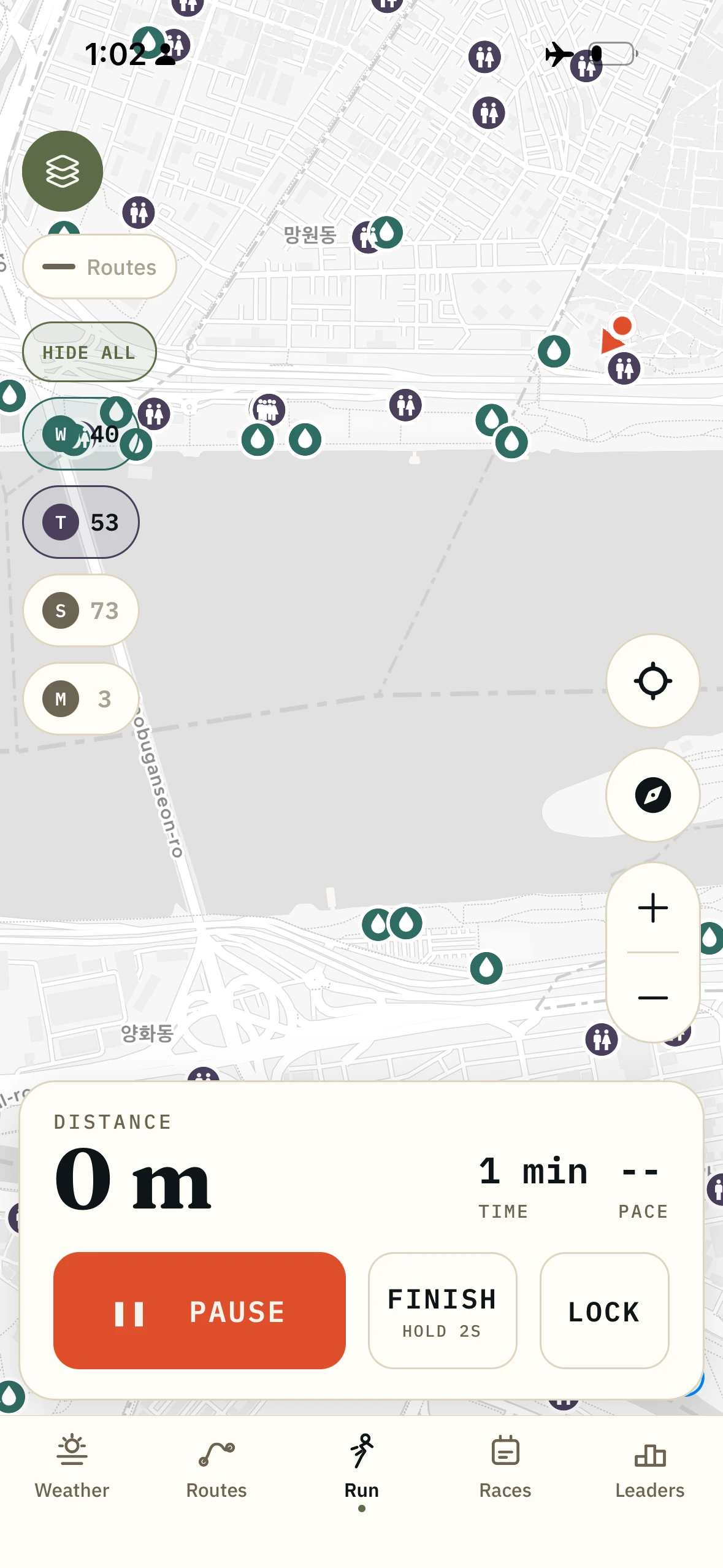
Water, toilets, stores and subway stations each get their own toggle, so at 6am you see only what you are looking for. Tap a pin for the straight-line distance from where you stand, plus opening hours where the city publishes them.
02
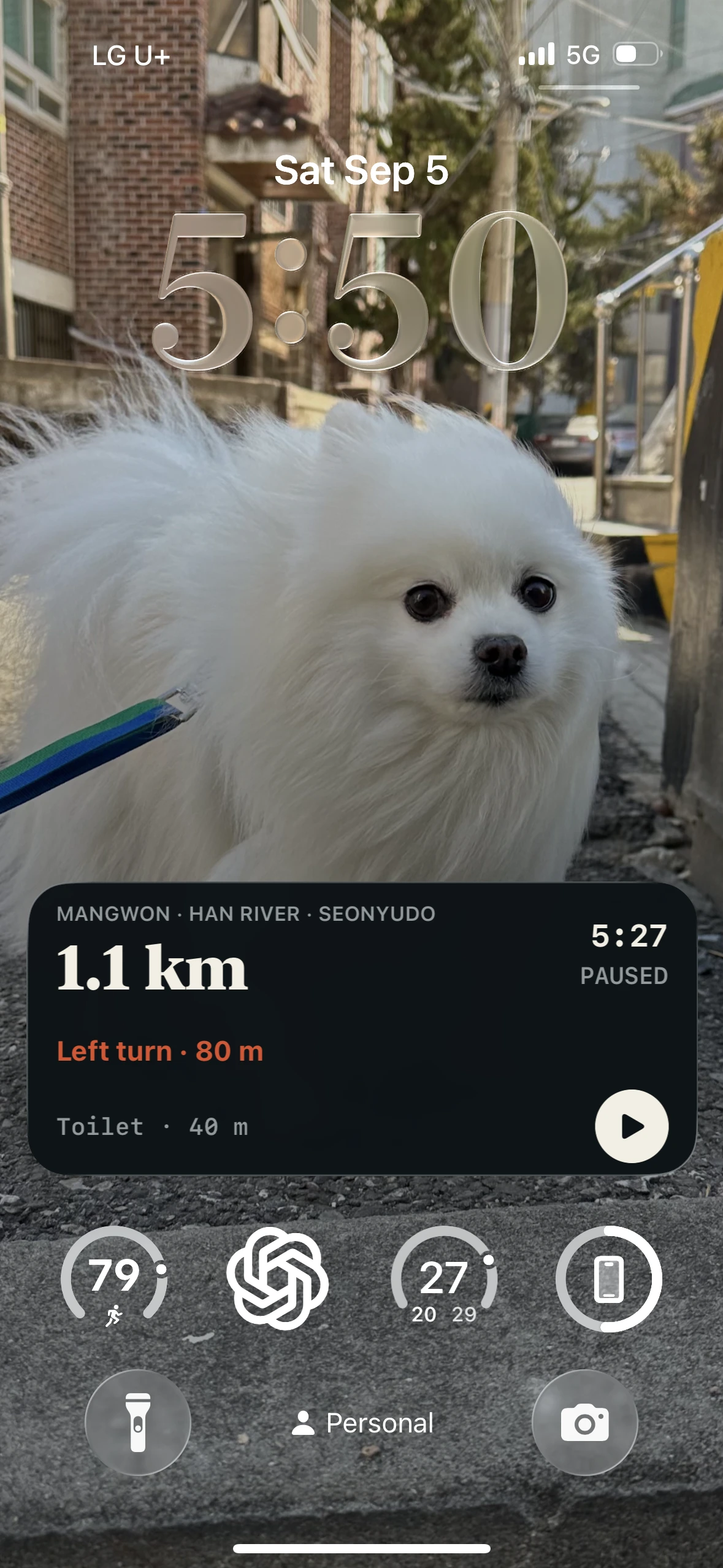
On a route, it names what is coming.
Follow a route and the app names the next stop ahead: the nearest tap, toilet or store within five kilometres. On iPhone that line sits on the lock screen under your pace, so the phone stays in your pocket.
03
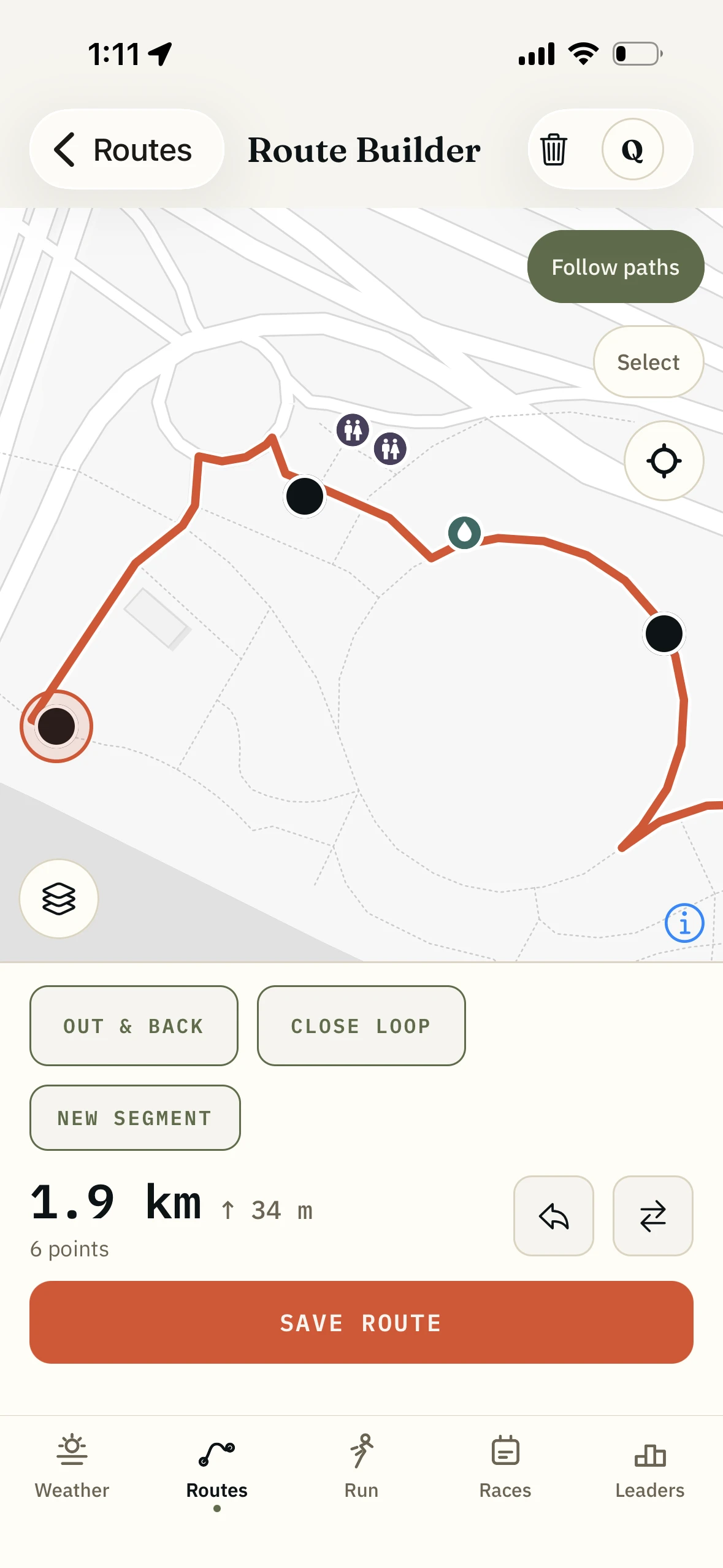
Draw the long run around the taps.
The same pins sit under the route builder while you draw. Pull the line two hundred metres to pass a fountain at 15K, or finish it at a convenience store so there is cold barley tea at the end.
04
It keeps working when the signal does not.
The pins, the distances and the next stop ahead survive an underpass, a tunnel and a dead signal at the far end of the river. Download the Seoul map pack once for the tiles under them.
What is on the map.
- Public toilets
- 4,446 across Seoul
- Water fountains
- 1,684 across Seoul
- Convenience stores
- 1,144, colour-coded by chain. Coverage follows the routes rather than the whole city
- Subway
- 784 stations and 2,142 station exits, on their own toggle
- On a 10K
- The median route in the app passes 15 public toilets and 7 water fountains every 10km
- Where the data comes from
- Seoul city open data for toilets and Arisu fountains, the SEMS commercial-district dataset on data.go.kr for stores
- Coverage
- Seoul. The rest of the app works anywhere; these places do not
- On a route
- Anything within 150m of the line counts as on it
- Next stop ahead
- The nearest tap, toilet or store within 5km, named on screen and on the iPhone lock screen
- Price
- Free, no account
Who it is for.
You are at kilometre 18 and out of water.
The thirst is not what ruins the run. Not knowing whether the answer is 400 metres away or four kilometres does. One is a target you can run to; the other takes over the rest of the run.
Your stomach changed its mind.
Everyone who runs in the morning has had this happen. Knowing where the toilets are is the difference between a run and a decision not to run.
You are going long in August.
Seoul in July and August takes more out of you than the pace suggests. Passing the last fountain without knowing it was the last one is how a 30K becomes a walk home.
You just moved here.
New building, new neighbourhood, no idea what is around the corner. The map knows the tap two streets over that you would not have found for another year.
What it is not.
The amenity map is not a review site.
It tells you a toilet is there, not whether it is clean or air-conditioned. It is a location database, not a ranking.
It is not a promise that the tap is on.
Seoul switches many fountains off through the cold months, and city data lags the real world in both directions. What the app promises is that a fountain was registered there, not that water comes out of it today.
It does not navigate you to the door.
You get the pin, the straight-line distance and the map. The last hundred metres are on you.
It does not speak.
The app calls your splits and turns out loud. Amenities are on the screen and the lock screen, not in your ears.
How it fits with the rest of the app.
- The route builder
The other half: shaping the run around the water before you leave.
- Curated Seoul routes
Routes I have run and checked myself carry their own water and toilets, counted before you start.
- Run tracking
The pins sit on the live run map too, so a free run with no route planned still answers the question.
Questions.
How far is the toilet?
Tap the pin and the app tells you, in metres, in a straight line from where you are standing. It says "straight line" on purpose: Seoul has a river through the middle of it, and a fountain 200 metres away across the water is a 1.5km round trip to the nearest bridge.
Do the pins work with no signal?
Yes, and that was the point of bundling them. The places sit inside the app rather than on a server, so an underpass or a dead spot changes nothing. Download the offline map pack from your profile and the basemap under the pins keeps working too.
Where does the data come from?
Public toilets and Arisu drinking fountains come from Seoul city open data. Convenience stores come from the SEMS commercial-district dataset on data.go.kr, which never retires a shop that has closed and runs two quarters behind. I correct records by hand.
Does it cover the rest of Korea?
Not for these places. The app records runs and builds routes anywhere. The water, toilets and stores are Seoul.
Do I pay for the water and toilet map?
No. All of it is free with no account, in the route builder, in a free run and while you follow a route.
A pin is wrong. Can I tell you?
Please do. quintin@runwithmeseoul.com. I take them out by hand.
Know where the next one is.
Water, toilets and convenience stores across Seoul, in the app, free, on iOS and Android.
The rest of the app.
- Curated Seoul routes64 routes, offline, turn by turn
- The route builderDraw a line, it snaps to runner paths
- GPS run trackingRecords offline, follows your route, GPX in and out
- The running weather scoreOne number for whether to run right now
- Leaderboards and friendsWhole routes, not segments, among people you know
- The Korea race calendar400+ races, with an alarm before entries open